1.
a) Sketch by hand a model, using the correct symbology, that uses the ‘POLYRAS’ module to rasterize a vector file named ‘Education’, then overlays the new ‘Education’ raster with a raster file image named ‘Malaria’. [1 mark]
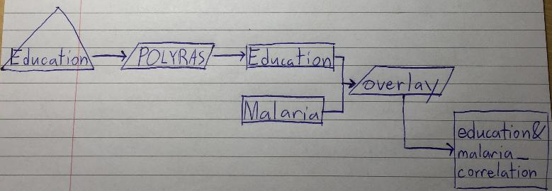
b) Give an example of a research question that leads you to overlay these two rasters. [1 mark]
Is there any correlation between the education and malaria across space? Is there a way to minimize cases of malaria using geographic data? Could this cartographic model help us save lives?
2.
a) What are the two fundamental types of query in GIS?
Spatial queries and attribute queries .
b) Give an example of each type of GIS query, in the form of a question.
Spatial query: How many golf courses can be found 100m from a Canadian highway?
Attribute query: Which cities have a population greater than 1 million?
c) What is the difference between a working folder and a resource folder?
The resource folder is where data (ex: “drelief.RST”) is taken from and the working folder is where the new data is sent. When Terrset is searching for a file it looks in the working folder first and then the resource folder.
d) What is the spatial resolution, reference units, and min/max values of drelief.RST?
Spatial resolution = (X) (Y) resolution = 30m X 30m.
Reference units = meters (m).
Min value = 5.000,000.
Max value = 15.999,967.
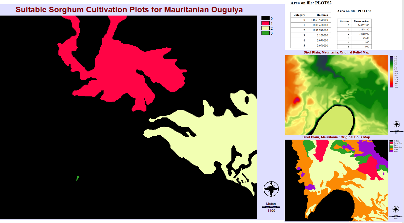
e) Give an appropriate, one-sentence research question for the task in this exercise (working with the DEM and soil type rasters).
Which areas are suitable recessional sorghum plots if these areas need to be flooded and composed of clay soil?
f) Bonus mark: in what town was the inventor of Boolean logic born? In what text did he publish his Boolean theory and what year was this? Give an example of two operations in ArcGIS that uses Boolean logic.
Born in the town of Lincoln, England.
In 1847 he published The Mathematical Analysis of Logic which introduced the Boolean theory.
OVERLAY can be used for the OR and AND Boolean operations.
g) How many square meters are suitable for sorghum cultivation?
37,718,100 square meters are suitable for sorghum cultivation.
h) The average price per hectare is 520 000 Mauritanian Ougulya. Calculate the estimated market value of each plot identified in this exercise.
plot 1: 520,000 X 1887.480000 = 981,489,600 dollars.
plot 2: 520,000 X 1881.990000 = 978,634,800 dollars.
| plot 3: 520,000 X 2.160000 = 1,123,200 dollars. |
i)
3.
Think about your research project topic for this course.
a) What is the research problem or issue you want to address?
b) What is your draft research question?
c) Provide one high-quality web-based or scholarly source of information on your topic (wiki, blogs, etc. are not appropriate here).
a)
Is there a way navigating through a large campus like SFU burnaby can be improved for the general public?
b)
By using augmented reality (AR) on people’s phones, campus navigation can be improved. This can be done by syncing a persons GPS location, gyroscopic orientation, and real world data to display phone visuals which can guide people towards their destination. Being able to hold a phone out and see arrows guiding to the next destination can be a major convenience. By improving navigation on campus people will be able to get to their classes quicker which will benefit everybody. I am interested how AR technology can be expanded upon and used for navigation in other locations.
c)
Qin Yong-Xu, Liu Jia-Min, Qiu Hui, Yan Bo, & Jin Chang-Xu. (2013). Campus Navigation System Based on Mobile Augmented Reality. Intelligent Networks and Intelligent Systems (ICINIS), 2013 6th International Conference on, 139-142.
